Latest Ukraine Satellite Images Shows The Magnitude Of Destruction
Ukraine Satellite Images
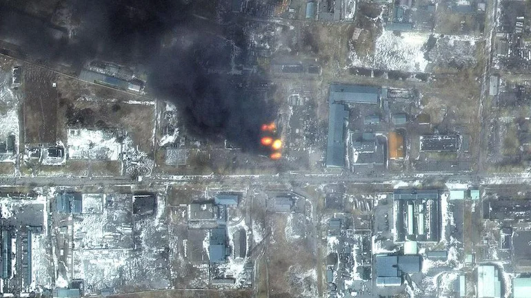
The latest album of destruction shows the magnitude of Russia’s attack. As the conflict between Ukraine and Russia enters the fourth week, the cities are facing powerful Russian airstrikes and artillery showers.
The satellite images are released by a US-based private company named Maxar Technologies. With these images, the amount of destruction that the cities of Ukraine are facing was revealed. Clearly shows the highly damaged apartments, residential areas, homes, and stores of Mariupol City.


Also read:
Another Scam Hits PNB, This Time Amount Is Rs.2060 Cr
Impact On Kyiv And Other Towns
With Ukraine Satellite Images, you can see the intense damage caused by the airstrikes and artillery in Kyiv city. Towns named Hostomel, Moschun, Irpin, and many others located in the Northwest of the city are facing critical situations. Destruction of grocery stores, residential buildings, stores, and other infrastructures can be seen clearly. These towns are witnessing some of the most horrible fighting events since the start of this invasion.
Near Antonov Airport in Hostomel and other regions, Russia has installed heavily armored equipment. To protect them Russian forces are continuously using the natural barriers called Berms.
Now Kyiv has blamed Moscow for engaging in war crimes for intensely shelling the residential areas. As per the officials since February 24th, 2500 people have died after the start of this invasion.
Call Of Ukrainian President
Ukraine’s President Volodymyr Zelensky called a meeting with Russia to stop the war and to warn “it would take several generations for Moscow to recover from battlefield losses if it does not reverse course.”
“I want everyone to hear me now, especially in Moscow. The time has come for a meeting, it is time to talk,” he said early on Saturday. “The time has come to restore territorial integrity and justice for Ukraine. Otherwise, Russia’s losses will be such that it will take you several generations to recover.”


